
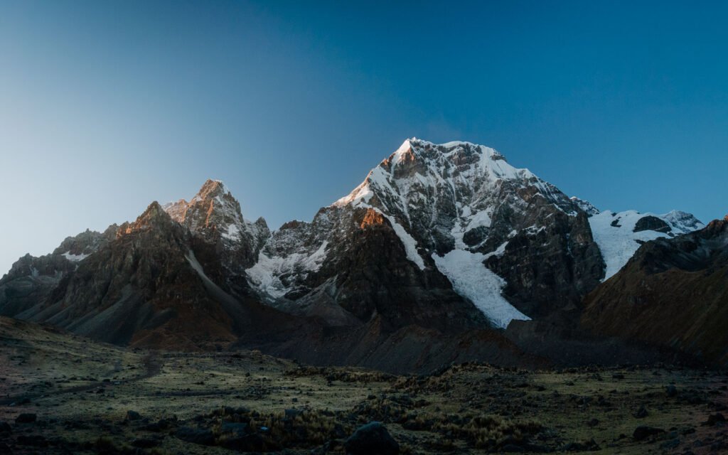
Quick answer: The Ausangate trek is a high-altitude hike around Ausangate (6,384 m), the highest mountain in the Cusco region, about 3.5 hours by road from Cusco. The classic circuit is a loop of about 70 km. It takes 4 to 6 days and crosses passes over 5,000 m. Shorter routes of 1 to 3 days visit the 7 Lakes, and the 3-day route adds Rainbow Mountain. The driest months are April to September.
Ausangate is the mountain we photograph most. It has glaciers, turquoise and red lakes, alpaca herds and families who still live at 4,500 m. It also gets far fewer visitors than Machu Picchu, Rainbow Mountain or the Salkantay trek. For us, it is the most underrated trek near Cusco. This guide explains the routes, the altitude, the best season and how to get good photos.
Ausangate trek routes: 1 to 6 days
The name “Ausangate trek” covers very different trips. Choose by your time and your fitness. Most tour operators run these routes with horses that carry your gear.
| Route | Days | What you see | Best for |
|---|---|---|---|
| 7 Lakes day hike | 1 | The 7 Lakes below the north face of Ausangate | People already used to the altitude, with only one day |
| 7 Lakes + Upis | 2 | Huayna Ausangate at sunset from Upis, and the 7 Lakes at sunrise | Photographers who want sunset and sunrise with one night out |
| Rainbow Mountain + Ausangate | 3 | Rainbow Mountain, Red Valley and glacier lakes (not the full circuit) | Two big landscapes in one trip. Moderate to hard, with long walking days |
| Classic circuit | 4–5 | The full loop around the mountain, with passes over 5,000 m. No Rainbow Mountain | Fit hikers who are well acclimatized |
| Classic circuit + Rainbow Mountain | 5–6 | The full loop plus Rainbow Mountain | Adventure lovers who want both places in good light. The 5-day version is only for experienced hikers |
How high is the Ausangate trek?
| Place | Altitude |
|---|---|
| Ausangate summit | 6,384 m (20,945 ft) |
| Palomani pass (highest point of the circuit) | about 5,165 m (16,946 ft) |
| Pacchanta (hot springs) | about 4,200 m (13,780 ft) |
| Tinqui (start and end of the circuit) | about 3,900 m (12,795 ft) |
On every route you sleep above 4,000 m. Nights are usually around 2 °C (36 °F). From June to August they often go below 0 °C (32 °F).
How hard is it?
The trail is not technical. The altitude is what makes it hard. Spend at least 2–3 days in Cusco first and do a few short hikes. Before the classic circuit, spend more days. On the passes, walk slowly and drink often. Add electrolytes to your water to replace the salts you lose while hiking.
The 1-day and 2-day routes are much easier than the full circuit. A vehicle drives you close to the trail and the camp, so you only carry a light bag.
Best time to do the Ausangate trek
| Months | Season | What to expect |
|---|---|---|
| April to September | Dry | Clear skies and the best glacier views. Very cold nights. Snow is possible from June to August |
| March and October | Shoulder (between seasons) | Warmer days, more clouds, some rain |
| November to early March | Rainy | Rain usually comes in the afternoon. Mornings are often clear. Green valleys and muddy trails |
For photographers, we recommend March to December. Skip only January and February, the wettest months. At the end of the rainy season, the colors are deeper and the clouds are more interesting. If you start early, you usually get a clear sunrise at the lakes before the clouds build up. Afternoons can also clear after a rainy morning. The weather changes fast, and that often gives the best light.
Can you combine Ausangate with Rainbow Mountain?
Yes. Rainbow Mountain (Vinicunca) is on the south-east side of the Ausangate range. The 3-day Rainbow Mountain and Ausangate route links both: Rainbow Mountain in the afternoon, after the day groups leave, and the glacier lakes the next morning. You can also add Rainbow Mountain to the full Ausangate circuit in 5–6 days. Read our guide to Rainbow Mountain without filters.
Guided trek or on your own?
A guide is not required by law. If you are an experienced backpacker and already acclimatized to 4,000 m, you can hike on your own with AllTrails or a good map. But the trail is not always marked, the weather changes fast, and each community on the way charges a small entrance fee in cash. Without good gear, the altitude and the cold are the hardest part.
An organized tour gives you comforts that matter up there:
- Hot, cooked meals at every camp.
- No heavy backpack. You walk with a light day bag.
- A guide who knows the route, the shortcuts and a plan B for bad weather.
- Someone to translate. Most families on the circuit speak Quechua and only a little Spanish. Your guide helps you talk with them.
- In our case, a guide who is also a photographer and understands light, timing and composition.
How we do the trek
We designed our Ausangate trips for photographers who want comfort at altitude:
- No horses on the trail. A vehicle carries the gear and drives to each camp.
- The route split into sections. You choose the north face, the south face or both. You skip the long hiking days and focus on your photos.
- Big tents and warm gear. Two people share a four-person tent. Sleeping bags are rated to −15 °C (5 °F), with liners and hot-water bottles.
- A plan B for bad weather. We know the area well. If it rains, we change the order of the day or go to another lake, so you don’t lose the light.
- Photo review every evening. Your guide looks at your photos with you and gives a short Lightroom lesson.
Photograph the 7 Lakes at sunrise and Huayna Ausangate at sunset. See our 7 Lakes of Ausangate and Upis photography tour.
Photography tips for Ausangate
- Shoot the lakes at first light. The water is calm and the glacier gets the first sun. By late morning, the wind breaks the reflections.
- Bring a polarizer. It cuts the glare on the water and brings out the turquoise.
- Pack ND filters. Use them for long exposures of streams and moving clouds.
- Use people and alpacas for scale. Ask families before you photograph them or their herds, and offer a fair payment.
- Keep batteries warm. At night, keep them inside your sleeping bag.
- Bring a drone if you can. It gives you many more angles on the lakes and glaciers. Ask the local community first, and do not fly close to the alpacas.
FAQ
How cold does it get on the Ausangate trek?
At night it is usually around 2 °C (36 °F). From June to August it often drops below 0 °C (32 °F). Bring a sleeping bag rated well below freezing and warm layers.
What is the highest point of the Ausangate trek?
The Palomani pass, at about 5,165 m (16,946 ft).
When is the best time to do the Ausangate trek?
April to September has the clearest skies. For photography, March to December gives deeper colors and more interesting clouds.
Can you do Ausangate and Rainbow Mountain together?
Yes. The 3-day route links Rainbow Mountain and the glacier lakes. You can also do the full circuit plus Rainbow Mountain in 5–6 days.
Do you need a guide for the Ausangate trek?
No, it is not required. Experienced backpackers who are well acclimatized can go alone. A local guide makes the trek safer and easier, and helps you talk with Quechua-speaking families.
Questions or comments? Write to us at info@photographyperu.com. We usually reply within 24 hours.